An overview of Eritrea’s historical development, colonial period, struggle for independence, and geographical significance.
Colonial Foundations and Early Governance (1890–1941)
Eritrea assumed its current geographical shape in 1890 with the arrival of Italian colonialism. Before 1890, the Eritrean people possessed their own diverse political and social centers, governed by internal laws and regional agreements.
For over 51 years (1890–1941), Eritrea lived under Italian rule until Italy was defeated by the Allied forces (Great Britain) during World War II.
British Administration and the Federation (1941–1962)
From 1941 until the establishment of the Federation between Eritrea and Ethiopia in 1952, the country was under British Military Administration.
During this period, the Eritrean people engaged in a fundamental national political struggle. Although this led to a federation with Ethiopia—initially described as a sustainable solution—the imbalance of power was quickly exploited by the Ethiopian state.
On August 14, 1962, after only ten years, Ethiopia unilaterally declared Eritrea its 14th province.
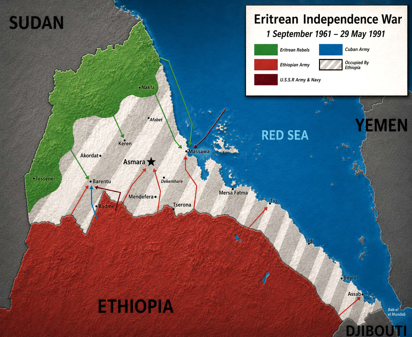
The Armed Struggle for Independence (1961–1991)
The armed struggle was launched on September 1, 1961, under the leadership of Hamid Idris Awate.
For 30 years, the Eritrean people waged a bloody war for survival against:
- The religious monarchy of Haile Selassie (1962–1974)
- The communist military regime of the Derg (1974–1991)
While many organizations contributed to the liberation, the two largest were:
The Eritrean Liberation Front (ELF / Jebha)
Active from: 1961
It played a decisive role in creating the national consciousness that defines Eritreans today.
Following a civil war between the two main organizations, it was pushed out of the field in 1981, though some members remain active in the struggle today in 2026.
The Eritrean People's Liberation Front (EPLF / Shaebia)
Formed in: 1970
Created by three groups that split from the ELF:
- People's Liberation Forces / Red Sea
- Independence Party / Ala Group
- Liberation Forces / Obel Group
It became a unified organization in 1977 and finally swept Ethiopian colonialism out of Eritrea by defeating the Derg military in 1991.
Ethnic Identity and Administrative Geography
Since 1996, the current government has recognized nine nationalities spread across six zones based on language.
However, many parties disagree with this linguistic definition.
For instance, there are groups like the Elite, Sihho, Dahalika, and Hausa who are part of the Eritrean identity but lack formal recognition of their languages.
The Nine Historical Provinces (Pre-1996)
- Barka
- Senhit
- Gash Setit
- Sahel
- Semhar
- Denkalia
- Akele Guzay
- Hamasien
- Seraye
Common regional terms:
- Kebessa — Highlands
- Metahit — Lowlands
Geography and Strategy
Eritrea covers 124,000 square kilometres in the Horn of Africa along the Red Sea.
It boasts a coastline of over 1,113 kilometres and more than 365 islands.
Land Borders:
- Sudan (West)
- Ethiopia (South)
- Djibouti (South-East)
Maritime Neighbors:
- Saudi Arabia
- Republic of Yemen
Key Gateways:
- Massawa
- Assab
- Zula
- Adulis
Support Eri Meeting Point
Keep independent media alive